





Gran Canaria is much more than sun and beaches. The island is like a continent in miniature, where rugged ravines, Canary Island pine forests and volcanic calderas sit side by side within a remarkably small area. Yet many visitors explore the island mainly by road and miss its extensive network of historic hiking trails, the Caminos Reales. These paths lead to remote places cars simply can't reach. On foot, the landscape feels different altogether: the scent of damp pine needles in the air, far from the bustle of the coast.
In this guide, you'll find some of the best hiking routes on Gran Canaria for different levels of difficulty, along with key technical details, directions, and practical tips for a rewarding hiking experience.
The best hiking routes in Gran Canaria: Experience nature up close
The island's trail network is the best way to get a feel for its microclimates and geology up close. From striking rock formations at almost 2,000 metres to hidden natural pools tucked between steep ravines, every route opens onto a different world.
1. Route to Roque Nublo: The Spiritual Heart of the Island
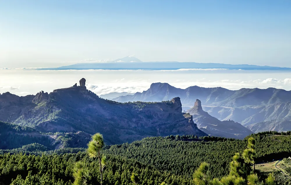
Roque Nublo impresses well beyond its sheer size. The roughly 80-metre-high rock monolith was once a sacred site for the island's indigenous people and is now one of Gran Canaria's best-known landmarks. It stands at an altitude of more than 1,800 metres in the municipality of Tejeda. The hike there is one of those experiences you shouldn't skip.
- Technical details:
- Distance: 4.5 km (round trip from La Goleta car park)
- Elevation gain: 160 m
- Difficulty: Easy to moderate
- Route type: Out-and-back along the same trail
- Estimated duration: 1 hour 45 minutes
- Landscape and experience: The hike begins among imposing Canary Island pines, sunlight filtering through the treetops in narrow beams onto the trail. As the gradient increases, the path grows rockier and the vegetation sparser, until little remains but bare, solidified lava that seems to shimmer in the heat. At the El Nublo pass, the wind often picks up, and the landscape opens into a sweeping panorama: the Caldera de Tejeda, Roque Bentayga and, on clear days, Mount Teide appearing to float above a sea of clouds on Tenerife. The final stretch across the plateau is the highlight — the sheer scale and silence of this roughly 4.5-million-year-old basalt massif make it hard not to fall quiet.
- Getting there and practical tips: The starting point is the La Goleta car park, accessible via the GC-600 from Tejeda or Cruz de Tejeda. If you're staying in the south of the island, expect around 60 minutes by car along winding but well-maintained mountain roads. An early start (before 9:30 am) or a late-afternoon hike around sunset is recommended — it also helps you dodge the heaviest traffic and the scramble for parking at peak times. Since February 2025, the Cabildo has required advance booking to access Roque Nublo. Make sure to arrange your permit ahead of time.
2. Route through the Caldera de Bandama: Down to the volcanic origins
In the northeast of the island lies the Caldera de Bandama, one of Gran Canaria's most impressive volcanic craters — around a kilometre across and more than 200 metres deep. Rather than climbing to a summit, this route takes you down into the heart of an extinct volcano.
- Technical details:
- Distance: 3 km (descent and ascent into the crater)
- Elevation gain: 200 m total ascent
- Difficulty: Moderate (due to the steep gradient)
- Route type: Circular route on the crater floor, with an out-and-back section for the descent and ascent
- Estimated duration: 1 hour and 30 minutes
- Landscape and experience: Descending over black volcanic sand and rock (picón), you'll notice the temperature climb as the crater walls shelter you from the wind. At the bottom, it's quiet — traffic noise is long gone, replaced by nothing more than the occasional call of a kestrel. An old settler's house and an abandoned wine press sit on the crater floor, surrounded by mastic shrubs, Canary Island palms and eucalyptus trees. The climb back up takes a reasonable level of fitness: the loose, sandy surface makes every step more tiring than it looks.
- Getting there and practical tips: The caldera is only around 20 minutes by car from Las Palmas de Gran Canaria and roughly 45 minutes from the south of the island. Take the GC-1 motorway followed by the GC-802. Parking is available at Pico de Bandama or near the crater entrance. The caldera can also be reached by public transport, including bus route 311. Shoes with good grip are essential for the descent, to avoid slipping on the loose surface.
3. Tamadaba Nature Park and Charco Azul: From Pine Forest to the Sea
In the northwest of the island lies Tamadaba Nature Park, one of the most unspoilt and least developed areas of Gran Canaria. One of its most appealing routes skips the pine forest altogether, following the ravine straight down to the sea instead: the hike to Charco Azul.
- Technical details (El Risco – Charco Azul section):
- Distance: 3.5 km (round trip)
- Elevation gain: 150 m
- Difficulty: Easy
- Route type: Out-and-back along the same trail
- Estimated duration: 1 hour 15 minutes
- Landscape and experience: The route follows the bed of the Barranco del Risco, flanked by steep rock faces and drought-resistant plants like euphorbia and candelabra cacti. As you near the sea, the dry scent of the vegetation gives way to the freshness of running water and salt air. At the end, a natural pool awaits, fed by a small waterfall in wetter months — dark rock, lush greenery and turquoise water make it a good spot to stop and take it all in.
- Getting there and practical tips: The starting point is the small hamlet of El Risco on the GC-200 between Agaete and La Aldea de San Nicolás. Winter and spring are the best seasons for this hike, ideally a few weeks after the rains, when the water level at Charco Azul is at its highest.
4. Llanos de la Pez Circular Route: Hiking Among the Peaks
If you're after a varied mountain hike with natural shade and elevations above 1,500 metres, the Llanos de la Pez and the Central Mountain Range are hard to beat. Flat sections alternate with wide, sweeping views.
- Technical details:
- Distance: 8.5 km
- Elevation gain: 320 m
- Difficulty: Moderate
- Route type: Circular route
- Estimated duration: 3 hours
- Landscape and experience: The scent of resin from the Canary Island pines and the crunch of dry needles underfoot set the pace for this hike. Thanks to the shade, temperatures stay pleasantly cool — a good choice even on warmer days. Trade-wind mist often drifts through the treetops, bathing the forest in an almost mystical light that's earned it the nickname "enchanted forest."
- Getting there and practical tips: The main access route is via the GC-150 from Cruz de Tejeda. Several well-equipped picnic areas with benches and trail maps can be found nearby.
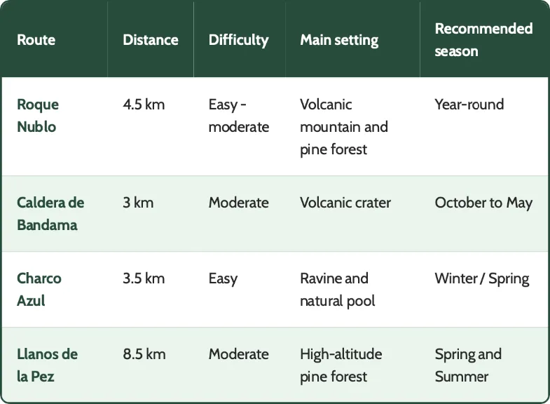
Comparison of best routes at a glance
Practical guide to hiking in Gran Canaria
Anyone heading into Gran Canaria's mountains should come prepared. The island's varied topography means altitude and weather can shift considerably within just a few kilometres — sunshine on the coast can give way to dense mountain fog within minutes. The right gear and a sense of the seasons make all the difference.
Essential Equipment
- Suitable footwear: Avoid everyday shoes or anything with smooth soles. Volcanic rock and picón are hard on soles and can get very slippery. Trail running shoes or ankle-high hiking boots with good grip are the best choice.
- Dress in layers: The three-layer system works well: a breathable shirt, a lightweight fleece for higher-altitude sections, and a windproof, waterproof jacket.
- Bring enough food and water: Take at least 1.5 litres of water per person. Unlike in the Alps, there are very few drinking-water sources along the trails here. Energy-rich snacks like nuts, bars, and bananas help keep you going.
- Sun protection: UV radiation is particularly intense at higher elevations. Use SPF 50+ sunscreen, sunglasses, and a cap or hat.
The Best Time of Year for Hiking
- Autumn and winter (October to March): These months are the island's prime hiking season. After the first autumn rains, the ravines turn green, mountain temperatures generally sit between 16 °C and 22 °C, and conditions are excellent for longer hikes.
- Spring (April to June): Almond and fig trees blossom, while the mountains come alive with the yellow of broom shrubs against the green of the pine forests.
- Summer (July to September): This is a tougher season for hiking in the higher regions, thanks to occasional heatwaves and possible calima — Saharan dust carried in the air. If you visit in summer, it’s best to start at sunrise or stick to shaded trails in the north.
Where to Stay in Gran Canaria When You Want to Combine Hiking and Relaxation
The right accommodation can make or break a trip that combines hiking with genuine relaxation. Thanks to the island’s short distances, you can hike in the mountains in the morning and be back by the Atlantic before the day’s out. Here’s why the south of the island makes such a well-balanced base for hikers.
The Ideal Balance Between Mountains and Relaxation by the Sea
Staying in the south of the island — in Maspalomas, say, or around the golf course — gives hikers a particularly convenient base, for three reasons:
- Reliable climate: The south enjoys mild temperatures and plenty of sunshine almost year-round. Even when the mountains are cloudy or cool, you can be back by the pool or on the beach the same afternoon.
- Good transport connections: Key roads, including the GC-60 linking Maspalomas, Fataga, San Bartolomé de Tirajana and the mountain regions, put many popular trailheads less than an hour away.
- Recovery after your hike: A demanding hike takes something out of you, and the body needs time to recover. The accommodation at Dunas Hotels & Resorts provides just that: spacious gardens, pools, and facilities built for relaxation and wellbeing — ideal for recharging before the next day on the trails.
